Europe Aviation Weather Report for Salzburg Airport (LOWS/SZG)
Decoded TAF & METAR reports Decoded for Salzburg Airport at 06:50 UTC on the 28th
Runways Available 15, 33
Below are the latest METAR & TAF reports for Salzburg Airport, as well as details for the nearest alternates.
The warning and threat levels in the METAR and TAF reports are currently being displayed for an airliner operating as a multi crew, CAT2/3 capable IFR flight, if you wish to change these thresholds to be more suitable for general aviation aircraft operating single crew VFR then use this drop down to select general aviation
METAR data is updated on the hour and half hour, TAF data is updated every few hours inline with its publication schedule.
Weather Decoded for Salzburg Airport at 06:50 UTC on the 28th
The follow is the current weather decoded from the most recently published METAR.
Almanac for daylight hours at Salzburg Airport, all times in UTC.
| Dawn Twilight | 02:31 |
| Sunrise | 03:09 |
| Sunset | 19:12 |
| Evening Twilight | 19:51 |
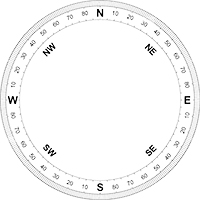
Wind
Direction: South Easterly
Magnetic: 150°
Speed: 8kts (12mph)
Visibility
Horizontal Visibility: Greater than 10km
Clouds
No clouds detected
Weather Phenomena
No precipitation detected
No significant change to the conditions expected
Temperature
Temperature: 28°
Dewpoint: 16°
Pressure
QNH: 1020
RAW METAR and TAF data for Salzburg Airport with threats highlighted based on your type of flight operation above.
METAR LOWS 280650Z AUTO 15008KT 9999 NCD 28/16 Q1020 NOSIG
METAR LOWS 280620Z AUTO 15007KT 9999 NCD 27/17 Q1020 NOSIG
METAR LOWS 280550Z AUTO 14008KT 110V170 9999 NCD 26/16 Q1019 NOSIG
METAR LOWS 280520Z AUTO 15009KT 9999 NCD 25/15 Q1019 NOSIG

| Runway 15 | |
|---|---|
| Headwind | Crosswind |
| 8 kts | 0 kts |
Wind favours runway 15 with a crosswind of 0 kts and a headwind of 8 kts
LOWS 280515Z 2806/2906 15005KT CAVOK TX36/2813Z TN21/2904Z
BECMG 2808/2810 34010KT
PROB30 TEMPO 2814/2821 32020G35KT TSRA SCT090 FEW090CB
BECMG 2819/2821 15006KT
Not sure of an abbreviation in the TAF or just looking for a quick refresher on how to decode a TAF, check out our TAF decode guide.
Both the latest METAR and TAF are decoded into plain text with hour by hour synopsis in the expanded decoded weather tab.
The nearest 4 alternate airport's weather is also avaiable via the Alternates tab.
The following is the forecast presented in hour segments from the most recently published TAF above.
Notes for using the following -
1) BECMG (becoming) assumes the change will occur at the end of the period listed, e.g. BECMG xx10/xx12, the new conditions will be present from 12 noon.
2) PROB30 are listed as Low Probability Temporary Conditions with PROB40 being listed as High Probability Temporary Conditions.
3) TEMPO are listed as Temporary Conditions, these conditions will be present for 50% of the time period.
4) All times are in UTC (zulu).
Forecast for period 06:00-07:00 on the 28th
Forecast for period 07:00-08:00 on the 28th
Forecast for period 08:00-09:00 on the 28th
Forecast for period 09:00-10:00 on the 28th
Forecast for period 10:00-11:00 on the 28th
Forecast for period 11:00-12:00 on the 28th
Forecast for period 12:00-13:00 on the 28th
Forecast for period 13:00-14:00 on the 28th
Forecast for period 14:00-15:00 on the 28th
Low Probability Temporary Conditions
Forecast for period 15:00-16:00 on the 28th
Low Probability Temporary Conditions
Forecast for period 16:00-17:00 on the 28th
Low Probability Temporary Conditions
Forecast for period 17:00-18:00 on the 28th
Low Probability Temporary Conditions
Forecast for period 18:00-19:00 on the 28th
Low Probability Temporary Conditions
Forecast for period 19:00-20:00 on the 28th
Low Probability Temporary Conditions
Forecast for period 20:00-21:00 on the 28th
Low Probability Temporary Conditions
Forecast for period 21:00-22:00 on the 28th
Forecast for period 22:00-23:00 on the 28th
Forecast for period 23:00-00:00 on the 28th
Forecast for period 00:00-01:00 on the 29th
Forecast for period 01:00-02:00 on the 29th
Forecast for period 02:00-03:00 on the 29th
Forecast for period 03:00-04:00 on the 29th
Forecast for period 04:00-05:00 on the 29th
Forecast for period 05:00-06:00 on the 29th
* Although every effort has been made to confirm the accuracy of these decode, the raw metar and TAF from above must be used for flight planning purposes.
** These decode are designed for civilian airports only, military decodes will most likely contain omissions or errors.
Planning a flight to or from Salzburg Airport?
You can check weather data for your entire route using our route search tool.
Below are the nearest 4 airports (potentially including general aviation or airports with runways shorter than 1600M, as well as military airports) from our database that may also be useful for your planning purposes, sorted in distance from Salzburg Airport.
Linz Airport (LOWL/LNZ)
Runways Available 08, 26
Distance 63 Nautical Miles
Clich here to see the full details for Linz Airport
| Wind Variable (max) | |
|---|---|
| Headwind | Crosswind |
| ~2 kts | ~2 kts |
Munich Airport (EDDM/MUC)
Runways Available 08L, 08R, 26L, 26R
Distance 68 Nautical Miles
Clich here to see the full details for Munich Airport
| Runway 26 | |
|---|---|
| Headwind | Crosswind |
| 9 kts | 2 kts |
Klagenfurt Airport (LOWK/KLU)
Runways Available 10L, 28R
Distance 101 Nautical Miles
Clich here to see the full details for Klagenfurt Airport
| Wind Variable (max) | |
|---|---|
| Headwind | Crosswind |
| ~2 kts | ~2 kts |
Bolzano Airport (LIPB/BZO)
Runways Available 01, 19
Distance 121 Nautical Miles
Clich here to see the full details for Bolzano Airport
| Wind Variable (max) | |
|---|---|
| Headwind | Crosswind |
| ~2 kts | ~2 kts |
Spotted an error with any of the airport information stored in our database?
Please let us know via the contact form.